IMAGES TAKEN NEAR TO
Brewers Grove, South Street, MAYFIELD, TN20 6DF
Introduction
This page details the photographs taken nearby to Brewers Grove, South Street, TN20 6DF by members of the Geograph project.
The Geograph project started in 2005 with the aim of publishing, organising and preserving representative images for every square kilometre of Great Britain, Ireland and the Isle of Man.

There are currently over 7.5m images from over14,400 individuals and you can help contribute to the project by visiting https://www.geograph.org.uk
Image Map (Loading...)


Getting Data...Please wait
Leaflet Map data © OpenStreetMap
Images are licensed for reuse under creativecommons.org/licenses/by-sa/2.0
Notes
- Clicking on the map will re-center to the selected point.
- The higher the marker number, the further away the image location is from the centre of the postcode.
Image Listing (253 Images Found)
Images are licensed for reuse under creativecommons.org/licenses/by-sa/2.0
Image
Details
Distance

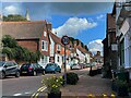
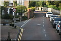
2
Slate Terrace, South Street, Mayfield
Dating from the 19th century and viewed from the junction with Vale Road.
Image: © Simon Carey
Taken: 29 Dec 2022
0.02 miles
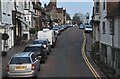
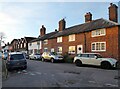
3
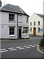
Junction of South Street and Vale Road
Image: © Ian Hawfinch
Taken: 11 Apr 2022
0.02 miles
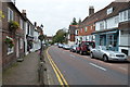
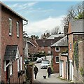
5
Corner House, West Street
Looks like a former shop or pub on the corner of West Street and South Street. Beyond is the Mayfield Baptist Church built in 1873.
Image: © Simon Carey
Taken: 23 May 2009
0.04 miles