IMAGES TAKEN NEAR TO
Heathfield Road, ETCHINGHAM, TN19 7LA
Introduction
This page details the photographs taken nearby to Heathfield Road, TN19 7LA by members of the Geograph project.
The Geograph project started in 2005 with the aim of publishing, organising and preserving representative images for every square kilometre of Great Britain, Ireland and the Isle of Man.

There are currently over 7.5m images from over14,400 individuals and you can help contribute to the project by visiting https://www.geograph.org.uk
Image Map (Loading...)


Getting Data...Please wait
Leaflet Map data © OpenStreetMap
Images are licensed for reuse under creativecommons.org/licenses/by-sa/2.0
Notes
- Clicking on the map will re-center to the selected point.
- The higher the marker number, the further away the image location is from the centre of the postcode.
Image Listing (88 Images Found)
Images are licensed for reuse under creativecommons.org/licenses/by-sa/2.0
Image
Details
Distance
1
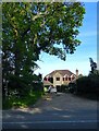
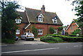
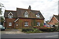
Dumbledore, Heathfield Road, Burwash Weald
Located on the eastern edge of the hamlet.
Image: © Simon Carey
Taken: 29 May 2023
0.00 miles
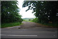
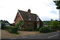
10
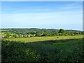
Six Acres
The name of the field according to Burwash's 1839 tithe map located to the south of Heathfield Road, the A265. Blackbrooks is the wood in the distance.
Image: © Simon Carey
Taken: 29 May 2023
0.08 miles