IMAGES TAKEN NEAR TO
Witherenden Hill, ETCHINGHAM, TN19 7JJ
Introduction
This page details the photographs taken nearby to Witherenden Hill, TN19 7JJ by members of the Geograph project.
The Geograph project started in 2005 with the aim of publishing, organising and preserving representative images for every square kilometre of Great Britain, Ireland and the Isle of Man.

There are currently over 7.5m images from over14,400 individuals and you can help contribute to the project by visiting https://www.geograph.org.uk
Image Map
Images are licensed for reuse under creativecommons.org/licenses/by-sa/2.0
Notes
- Clicking on the map will re-center to the selected point.
- The higher the marker number, the further away the image location is from the centre of the postcode.
Image Listing (8 Images Found)
Images are licensed for reuse under creativecommons.org/licenses/by-sa/2.0
Image
Details
Distance
1
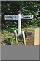
Old Direction Sign - Signpost by Peartree Hill, Burwash Parish
Black iron cap finial - 2 arms; East Sussex wood by the UC road, in parish of Burwash (Rother District), by Peartree Hill, Witherenden Hill, on verge at T-junction with unnamed road.
Surveyed
Milestone Society National ID: SX_TQ6426B.
Image: © Milestone Society
Taken: Unknown
0.06 miles
2
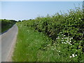
Lane at Witherenden Hill
This was a perfect summer's day.
Image: © Marathon
Taken: 5 Jun 2016
0.11 miles
3
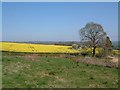
Oil seed rape crop in flower
A High Weald landscape in spring, near Witherenden Hill
Image: © David Saunders
Taken: 5 Apr 2001
0.15 miles
5
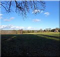
Orchard Field
The name of the field according to Burwash's 1839 tithe map located to the north of Bines Lane.
Image: © Simon Carey
Taken: 26 Dec 2022
0.20 miles
6
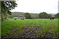
Fields near Bines Farm
The ground is starting to get soft, as can be seen by the tyre marks.
Image: © Julian P Guffogg
Taken: 20 Oct 2013
0.22 miles
7
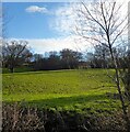
Denshare Field
The name of the field according to Burwash's 1839 tithe map located on the southern side of the River Rother.
Image: © Simon Carey
Taken: 26 Dec 2022
0.23 miles
8
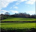
Footway Meadow/Hell Hams
The name of the fields according to Burwash's 1839 tithe map. Footway Meadow is in the foreground adjacent to the River Rother whilst Hell Hams is on the slope.
Image: © Simon Carey
Taken: 26 Dec 2022
0.23 miles