IMAGES TAKEN NEAR TO
Burwash, ETCHINGHAM, TN19 7HS
Introduction
This page details the photographs taken nearby to TN19 7HS by members of the Geograph project.
The Geograph project started in 2005 with the aim of publishing, organising and preserving representative images for every square kilometre of Great Britain, Ireland and the Isle of Man.

There are currently over 7.5m images from over14,400 individuals and you can help contribute to the project by visiting https://www.geograph.org.uk
Image Map
Images are licensed for reuse under creativecommons.org/licenses/by-sa/2.0
Notes
- Clicking on the map will re-center to the selected point.
- The higher the marker number, the further away the image location is from the centre of the postcode.
Image Listing (108 Images Found)
Images are licensed for reuse under creativecommons.org/licenses/by-sa/2.0
Image
Details
Distance
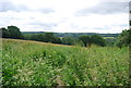
1
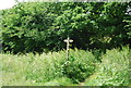
Ash Field
The name of the field according to Burwash's 1839 tithe map that is located to the north of the public footpath that links High Street to Bateman's Lane.
Image: © Simon Carey
Taken: 22 Mar 2020
0.08 miles
2
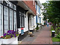
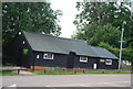
West End Burwash
This High Weald village's High Street has many buildings dating back to 17th & 18th Centuries. Note the brick pavement, white weatherboarding and the tile-hung first floor.
Image: © Colin Smith
Taken: 27 Aug 2006
0.09 miles
3

Burwash Village
Burwash is a small village with one road and a Norman Church surrounded by lovely countryside.The sign depicts the old iron industry of the area
Image: © Janet Richardson
Taken: 10 Oct 2005
0.10 miles
4
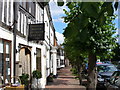
Burwash High Street
This old High Wealden village is much visited for its old buildings. Chateaubriand is reputed to be its oldest, dating back to ca 1380. It is now an antiques shop. Note the brick pavement and the line of trees, like an avenue.
Image: © Colin Smith
Taken: 27 Aug 2006
0.10 miles
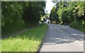
7
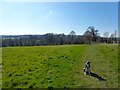
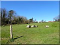
Upper Hams
The name of the field according to Burwash's 1839 tithe map that is located to the south of the public footpath that links the High Street to Bateman's Lane.
Image: © Simon Carey
Taken: 22 Mar 2020
0.12 miles