IMAGES TAKEN NEAR TO
Dairy Close, ETCHINGHAM, TN19 7FA
Introduction
This page details the photographs taken nearby to Dairy Close, TN19 7FA by members of the Geograph project.
The Geograph project started in 2005 with the aim of publishing, organising and preserving representative images for every square kilometre of Great Britain, Ireland and the Isle of Man.

There are currently over 7.5m images from over14,400 individuals and you can help contribute to the project by visiting https://www.geograph.org.uk
Image Map
Images are licensed for reuse under creativecommons.org/licenses/by-sa/2.0
Notes
- Clicking on the map will re-center to the selected point.
- The higher the marker number, the further away the image location is from the centre of the postcode.
Image Listing (19 Images Found)
Images are licensed for reuse under creativecommons.org/licenses/by-sa/2.0
Image
Details
Distance
1
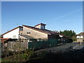
Hurst Green Primary School
On the A21 London Road.
Image: © David Anstiss
Taken: 18 Nov 2012
0.03 miles
2
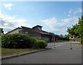
Hurst Green Church of England Primary School
The current building dates from around 2005 when it replaced the former 19th century school that is now its playing field.
Image: © Simon Carey
Taken: 26 Aug 2022
0.06 miles
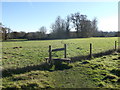
4
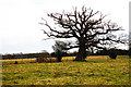
Barn Meadow
The name of the field according to Salehurst's 1841 tithe map bounded to the east by London Road, the A21. Burgh Wood can be seen in the distance.
Image: © Simon Carey
Taken: 26 Aug 2022
0.07 miles
5
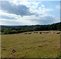
Footpath to Little Iridge Farm
Leading from the A21 London Road, through several fields.
Image: © David Anstiss
Taken: 18 Nov 2012
0.10 miles
6
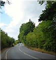
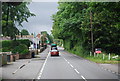
London Road
The A21 as it heads north from Silver Hill to Hurst Green.
Image: © Simon Carey
Taken: 26 Aug 2022
0.10 miles
7
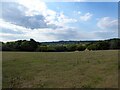
The Meadow
The name of the field according to Salehurst's 1841 tithe map located on the western side of London Road, the A21.
Image: © Simon Carey
Taken: 26 Aug 2022
0.13 miles
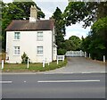
8
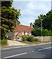
Ravensden, London Road, Hurst Green
A listed building dating back to the 17th century.
Image: © Simon Carey
Taken: 26 Aug 2022
0.14 miles
10
74, London Road, Hurst Green
A former lodge for Iridge Place dating from the late 19th century.
Image: © Simon Carey
Taken: 26 Aug 2022
0.17 miles