IMAGES TAKEN NEAR TO
Shrub Lane, ETCHINGHAM, TN19 7EB
Introduction
This page details the photographs taken nearby to Shrub Lane, TN19 7EB by members of the Geograph project.
The Geograph project started in 2005 with the aim of publishing, organising and preserving representative images for every square kilometre of Great Britain, Ireland and the Isle of Man.

There are currently over 7.5m images from over14,400 individuals and you can help contribute to the project by visiting https://www.geograph.org.uk
Image Map
Images are licensed for reuse under creativecommons.org/licenses/by-sa/2.0
Notes
- Clicking on the map will re-center to the selected point.
- The higher the marker number, the further away the image location is from the centre of the postcode.
Image Listing (14 Images Found)
Images are licensed for reuse under creativecommons.org/licenses/by-sa/2.0
Image
Details
Distance
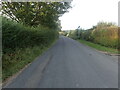
3
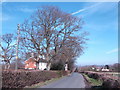
Battenhurst Road looking north
Near Acorn Farm
Image: © Jonathan Billinger
Taken: 7 Feb 2007
0.07 miles
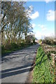
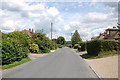
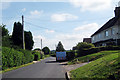
5
Shrub Lane
This is at the northern edge of Burwash.
Image: © Marathon
Taken: 12 Sep 2021
0.13 miles
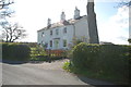
6
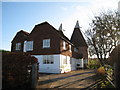
The Oast House, Shrub Lane, Burwash, East Sussex
Image: © Oast House Archive
Taken: 14 Nov 2007
0.15 miles
8
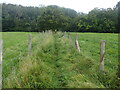
Footpath to Park Wood
The footpath leads from Shrub Lane and through Park Wood before heading uphill to the A265.
Image: © Marathon
Taken: 19 Sep 2021
0.21 miles
9
Battenhurst Road
Towards Stonegate
Image: © Oast House Archive
Taken: 4 Jun 2009
0.22 miles
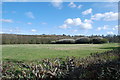
10
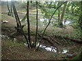
Pond and ditch in Park Wood
This is seen here from the footpath between Shrub Lane and the A265.
Image: © Marathon
Taken: 19 Sep 2021
0.22 miles