IMAGES TAKEN NEAR TO
Oxenbridge Lane, ETCHINGHAM, TN19 7DA
Introduction
This page details the photographs taken nearby to Oxenbridge Lane, TN19 7DA by members of the Geograph project.
The Geograph project started in 2005 with the aim of publishing, organising and preserving representative images for every square kilometre of Great Britain, Ireland and the Isle of Man.

There are currently over 7.5m images from over14,400 individuals and you can help contribute to the project by visiting https://www.geograph.org.uk
Image Map
Images are licensed for reuse under creativecommons.org/licenses/by-sa/2.0
Notes
- Clicking on the map will re-center to the selected point.
- The higher the marker number, the further away the image location is from the centre of the postcode.
Image Listing (26 Images Found)
Images are licensed for reuse under creativecommons.org/licenses/by-sa/2.0
Image
Details
Distance


3

Oxenbridge Lane
Heading into Etchingham.
Image: © N Chadwick
Taken: 23 Jun 2013
0.04 miles
5

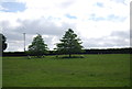
Grove Field
The name of the field according to Etchingham's 1838 tithe map located on the eastern side of Oxenbridge Lane.
Image: © Simon Carey
Taken: 3 Jun 2023
0.07 miles

7

Trees
Can anyone identify these two for me please as my tree identification skills are pretty poor. Located at the southern end of Image
Image: © Simon Carey
Taken: 3 Jun 2023
0.08 miles

9
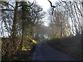
Oxenbridge Lane
This lane leads up through Old Woman's Wood towards Ludpits Lane.
Image: © David Anstiss
Taken: 2 Dec 2012
0.11 miles
10

Marlpit Field/Six Acres
The name of the fields according to Etchingham's 1838 tithe map that have been merged. Marlpit Field was in the foreground adjacent to Oxenbridge Lane whilst Six Acres was to the north with Sores Wood to the west.
Image: © Simon Carey
Taken: 3 Jun 2023
0.12 miles