IMAGES TAKEN NEAR TO
Etchingham Road, ETCHINGHAM, TN19 7BG
Introduction
This page details the photographs taken nearby to Etchingham Road, TN19 7BG by members of the Geograph project.
The Geograph project started in 2005 with the aim of publishing, organising and preserving representative images for every square kilometre of Great Britain, Ireland and the Isle of Man.

There are currently over 7.5m images from over14,400 individuals and you can help contribute to the project by visiting https://www.geograph.org.uk
Image Map (Loading...)


Getting Data...Please wait
Leaflet Map data © OpenStreetMap
Images are licensed for reuse under creativecommons.org/licenses/by-sa/2.0
Notes
- Clicking on the map will re-center to the selected point.
- The higher the marker number, the further away the image location is from the centre of the postcode.
Image Listing (24 Images Found)
Images are licensed for reuse under creativecommons.org/licenses/by-sa/2.0
Image
Details
Distance
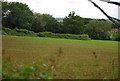
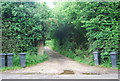
1
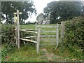
Looking towards Glebe House
This view is from a footpath leading from the busy A265 to reach Burwash Churchyard. Glebe House was formerly the rectory. It has a facade of 1721.
Image: © Marathon
Taken: 19 Sep 2021
0.01 miles
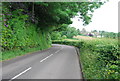
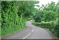

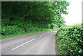
9
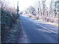
A265 west towards Burwash
About 100 yards of this road passes through the gridsquare.
Image: © Jonathan Billinger
Taken: 7 Feb 2007
0.13 miles