IMAGES TAKEN NEAR TO
The Orchard, ETCHINGHAM, TN19 7AW
Introduction
This page details the photographs taken nearby to The Orchard, TN19 7AW by members of the Geograph project.
The Geograph project started in 2005 with the aim of publishing, organising and preserving representative images for every square kilometre of Great Britain, Ireland and the Isle of Man.

There are currently over 7.5m images from over14,400 individuals and you can help contribute to the project by visiting https://www.geograph.org.uk
Image Map
Images are licensed for reuse under creativecommons.org/licenses/by-sa/2.0
Notes
- Clicking on the map will re-center to the selected point.
- The higher the marker number, the further away the image location is from the centre of the postcode.
Image Listing (170 Images Found)
Images are licensed for reuse under creativecommons.org/licenses/by-sa/2.0
Image
Details
Distance
2
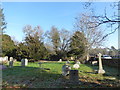
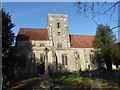
The Assumption of Blessed Mary and St Nicholas, Etchingham: a frosty churchyard
Image: © Basher Eyre
Taken: 21 Jan 2019
0.04 miles
3
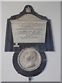
The Assumption of Blessed Mary and St Nicholas, Etchingham: memorial (a)
Image: © Basher Eyre
Taken: 21 Jan 2019
0.04 miles
4

The Assumption of Blessed Mary and St Nicholas, Etchingham: children's area
Image: © Basher Eyre
Taken: 21 Jan 2019
0.04 miles
5
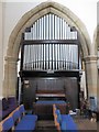
The Assumption of Blessed Mary and St Nicholas, Etchingham: organ
Image: © Basher Eyre
Taken: 21 Jan 2019
0.04 miles
6
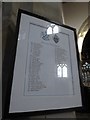
The Assumption of Blessed Mary and St Nicholas, Etchingham: incumbency board
Image: © Basher Eyre
Taken: 21 Jan 2019
0.04 miles
7
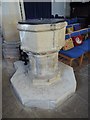
The Assumption of Blessed Mary and St Nicholas, Etchingham: font
Image: © Basher Eyre
Taken: 21 Jan 2019
0.04 miles
8

The Assumption of Blessed Mary and St Nicholas, Etchingham: artwork
Image: © Basher Eyre
Taken: 21 Jan 2019
0.04 miles
9
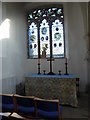
The Assumption of Blessed Mary and St Nicholas, Etchingham: side altar
Image: © Basher Eyre
Taken: 21 Jan 2019
0.04 miles
10

The Assumption and St Nicholas Church, Etchingham
Built in the 1360s and originally moated to prevent flooding from the nearby Rivers Rother and Dudwell. The depression in the foreground may well be the remains of the original moat which also enclosed the old manor house whose site now lies underneath the nearby station. Viewed from the Queen's Gardens, a small recreation ground opened in 1953.
Image: © Simon Carey
Taken: 6 May 2018
0.04 miles