IMAGES TAKEN NEAR TO
Hawkhurst, CRANBROOK, TN18 5ZL
Introduction
This page details the photographs taken nearby to TN18 5ZL by members of the Geograph project.
The Geograph project started in 2005 with the aim of publishing, organising and preserving representative images for every square kilometre of Great Britain, Ireland and the Isle of Man.

There are currently over 7.5m images from over14,400 individuals and you can help contribute to the project by visiting https://www.geograph.org.uk
Image Map (Loading...)


Getting Data...Please wait
Leaflet Map data © OpenStreetMap
Images are licensed for reuse under creativecommons.org/licenses/by-sa/2.0
Notes
- Clicking on the map will re-center to the selected point.
- The higher the marker number, the further away the image location is from the centre of the postcode.
Image Listing (459 Images Found)
Images are licensed for reuse under creativecommons.org/licenses/by-sa/2.0
Image
Details
Distance
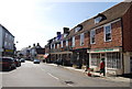
1
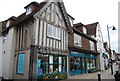
Lloyds Pharmacy, Cranbrook
In White Lion House on Cranbrook High Street. This was a former Inn.
Image: © David Anstiss
Taken: 20 Sep 2009
0.00 miles
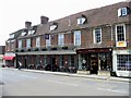
3
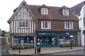
Half timbered pharmacy, High St, Cranbrook.
Image: © N Chadwick
Taken: 10 Apr 2010
0.02 miles
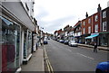
4
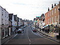
Stone St, Cranbrook
Note the George Hotel on the right.
Image: © N Chadwick
Taken: 10 Apr 2010
0.02 miles
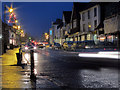
9
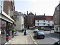
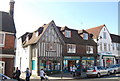
Cranbrook High Street
On the left is Carriers Road and the High Street turns the corner into Stone Street
Image: © Nick Smith
Taken: 10 Jul 2008
0.02 miles