IMAGES TAKEN NEAR TO
Ethnam Lane, CRANBROOK, TN18 5PS
Introduction
This page details the photographs taken nearby to Ethnam Lane, TN18 5PS by members of the Geograph project.
The Geograph project started in 2005 with the aim of publishing, organising and preserving representative images for every square kilometre of Great Britain, Ireland and the Isle of Man.

There are currently over 7.5m images from over14,400 individuals and you can help contribute to the project by visiting https://www.geograph.org.uk
Image Map (Loading...)


Getting Data...Please wait
Leaflet Map data © OpenStreetMap
Images are licensed for reuse under creativecommons.org/licenses/by-sa/2.0
Notes
- Clicking on the map will re-center to the selected point.
- The higher the marker number, the further away the image location is from the centre of the postcode.
Image Listing (30 Images Found)
Images are licensed for reuse under creativecommons.org/licenses/by-sa/2.0
Image
Details
Distance
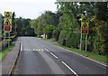
1
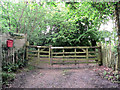
Cottage gate
There are several cottages at the beginning of Ethnam Lane. Pulling out into the main road just to the north can be a frightening experience.
Image: © RH Dengate
Taken: 1 Jun 2007
0.08 miles
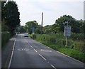
2
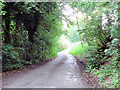
Ethnam Lane
This is a farm road leading down to the Rother valley. It is a dead end.
Image: © RH Dengate
Taken: 1 Jun 2007
0.12 miles
3
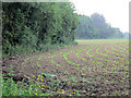
Maize field
Almost all maize in this area is used to make silage for cattle feed.
Image: © RH Dengate
Taken: 1 Jun 2007
0.14 miles
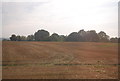
5
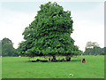
Parkland landscape, Sandhurst.
This is the field to the south of Stone House.
Image: © RH Dengate
Taken: 1 Jun 2007
0.15 miles

9
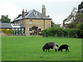
Stone House, Sandhurst
Apart from the parish church there are almost no other buildings in the village made of what is probably local stone. Stone Pit Lane is nearby.
Image: © RH Dengate
Taken: 1 Jun 2007
0.19 miles
10
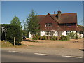
The Harrier Cafe
On the A268 in Linkhill. Former public house (The Harrier Inn), then converted into a house. Now a cafe.
Image: © David Anstiss
Taken: 23 May 2010
0.20 miles