IMAGES TAKEN NEAR TO
Pound Field, CRANBROOK, TN18 5LA
Introduction
This page details the photographs taken nearby to Pound Field, TN18 5LA by members of the Geograph project.
The Geograph project started in 2005 with the aim of publishing, organising and preserving representative images for every square kilometre of Great Britain, Ireland and the Isle of Man.

There are currently over 7.5m images from over14,400 individuals and you can help contribute to the project by visiting https://www.geograph.org.uk
Image Map
Images are licensed for reuse under creativecommons.org/licenses/by-sa/2.0
Notes
- Clicking on the map will re-center to the selected point.
- The higher the marker number, the further away the image location is from the centre of the postcode.
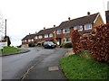
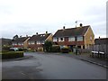
Image Listing (134 Images Found)
Images are licensed for reuse under creativecommons.org/licenses/by-sa/2.0
Image
Details
Distance
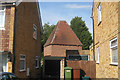
3
The Oast, Tanyard Farm, Bodiam Road, Sandhurst, Kent
Top of oast as viewed from Bodiam Road.
Image: © Oast House Archive
Taken: 23 Jun 2010
0.01 miles
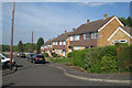
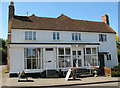
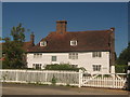
7
The White Cottage
On the A268 Queen Street. A traditional kentish wood panelled cottage.
Image: © David Anstiss
Taken: 23 May 2010
0.04 miles
9
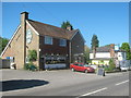
New Swan Public House, Sandhurst
On the A268 Queen Street.
Image: © David Anstiss
Taken: 23 May 2010
0.05 miles
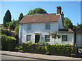
10
Old Swan House
On Bodiam Road, opposite Back Road.
Note; the large lead sundial on the wall.
Image: © David Anstiss
Taken: 23 May 2010
0.05 miles