IMAGES TAKEN NEAR TO
Rye Road, CRANBROOK, TN18 5JG
Introduction
This page details the photographs taken nearby to Rye Road, TN18 5JG by members of the Geograph project.
The Geograph project started in 2005 with the aim of publishing, organising and preserving representative images for every square kilometre of Great Britain, Ireland and the Isle of Man.

There are currently over 7.5m images from over14,400 individuals and you can help contribute to the project by visiting https://www.geograph.org.uk
Image Map (Loading...)


Getting Data...Please wait
Leaflet Map data © OpenStreetMap
Images are licensed for reuse under creativecommons.org/licenses/by-sa/2.0
Notes
- Clicking on the map will re-center to the selected point.
- The higher the marker number, the further away the image location is from the centre of the postcode.
Image Listing (113 Images Found)
Images are licensed for reuse under creativecommons.org/licenses/by-sa/2.0
Image
Details
Distance

8
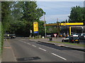
Jet Fuel Station
On Queen Street (A268) at junction with Back Forstall and Oaks Forstall.
Image: © Oast House Archive
Taken: 9 Jun 2010
0.07 miles
9
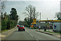
Jet fuel station, Sandhurst
Prices were 142.9 p/l petrol, 147.9 p/l diesel.
Image: © Robin Webster
Taken: 22 Mar 2012
0.07 miles
