IMAGES TAKEN NEAR TO
Whites Lane, CRANBROOK, TN18 5DD
Introduction
This page details the photographs taken nearby to Whites Lane, TN18 5DD by members of the Geograph project.
The Geograph project started in 2005 with the aim of publishing, organising and preserving representative images for every square kilometre of Great Britain, Ireland and the Isle of Man.

There are currently over 7.5m images from over14,400 individuals and you can help contribute to the project by visiting https://www.geograph.org.uk
Image Map (Loading...)


Getting Data...Please wait
Leaflet Map data © OpenStreetMap
Images are licensed for reuse under creativecommons.org/licenses/by-sa/2.0
Notes
- Clicking on the map will re-center to the selected point.
- The higher the marker number, the further away the image location is from the centre of the postcode.
Image Listing (8 Images Found)
Images are licensed for reuse under creativecommons.org/licenses/by-sa/2.0
Image
Details
Distance
2
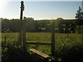
Stile on Water Lane
This stile is at the start of a footpath leading down to another footpath between Gun Green and Duvals Farm.
Image: © David Anstiss
Taken: 23 May 2010
0.19 miles

6

Bracket fungus
This was on the stump of a tree in White's Lane. Judging by the fact it also had fungus on it, it must have been here for some time.
Image: © Marathon
Taken: 1 Jan 2022
0.21 miles