IMAGES TAKEN NEAR TO
Hawkhurst, CRANBROOK, TN18 4XS
Introduction
This page details the photographs taken nearby to TN18 4XS by members of the Geograph project.
The Geograph project started in 2005 with the aim of publishing, organising and preserving representative images for every square kilometre of Great Britain, Ireland and the Isle of Man.

There are currently over 7.5m images from over14,400 individuals and you can help contribute to the project by visiting https://www.geograph.org.uk
Image Map (Loading...)


Getting Data...Please wait
Leaflet Map data © OpenStreetMap
Images are licensed for reuse under creativecommons.org/licenses/by-sa/2.0
Notes
- Clicking on the map will re-center to the selected point.
- The higher the marker number, the further away the image location is from the centre of the postcode.
Image Listing (43 Images Found)
Images are licensed for reuse under creativecommons.org/licenses/by-sa/2.0
Image
Details
Distance
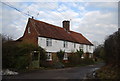
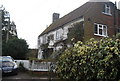
2
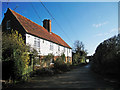
Pixhall Cottages, High Street
On a private track and public bridleway off the end of High Street.
Image: © Oast House Archive
Taken: 23 Jun 2010
0.01 miles
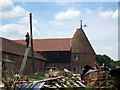
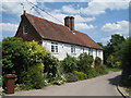
5
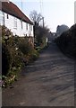
Pixhall Cottages, High Street, Hawkhurst, Kent
Although 'High Street' starts from the centre of Hawkhurst, 2 miles away, the name probably refers to a high road rather than a typical "High Street" of shops that one thinks of today.
Image: © Oast House Archive
Taken: 9 Mar 2009
0.03 miles
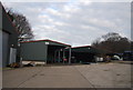
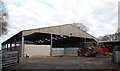
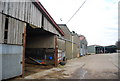
6
Little Pix Hall farm
The approach to Little Pix Hall farm, between Flimwell [East Sussex] and Hawkhurst [Kent]
Image: © Tim Knight
Taken: 26 Mar 2007
0.03 miles