IMAGES TAKEN NEAR TO
High Street, CRANBROOK, TN18 4AA
Introduction
This page details the photographs taken nearby to High Street, TN18 4AA by members of the Geograph project.
The Geograph project started in 2005 with the aim of publishing, organising and preserving representative images for every square kilometre of Great Britain, Ireland and the Isle of Man.

There are currently over 7.5m images from over14,400 individuals and you can help contribute to the project by visiting https://www.geograph.org.uk
Image Map
Images are licensed for reuse under creativecommons.org/licenses/by-sa/2.0
Notes
- Clicking on the map will re-center to the selected point.
- The higher the marker number, the further away the image location is from the centre of the postcode.
Image Listing (252 Images Found)
Images are licensed for reuse under creativecommons.org/licenses/by-sa/2.0
Image
Details
Distance
2
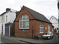
Infant School, Hawkhurst
On the A299 Cranbrook Road.
Was a school now used as a Cadet Drill Hall.
See Image for a close-up of the blue plaque on the building.
Image: © David Anstiss
Taken: 15 May 2011
0.01 miles
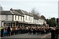
4
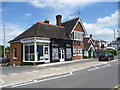
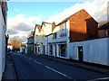
High Street, Hawkhurst
This view is right in the centre of the more modern part of Hawkhurst, near where High Street meets Rye Road, Cranbrook Road and Highgate Hill at the crossroads with its traffic lights. The original part of Hawkhurst is further south at The Moor.
Image: © Marathon
Taken: 1 Jul 2013
0.01 miles
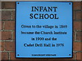
7
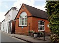
Former Infant School, Hawkhurst
The Infant School was opened in 1869 and then became the Church Institute in 1900. It became a Cadet Drill Hall in 1978.
Image: © nick macneill
Taken: 14 Jul 2012
0.02 miles
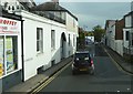
10
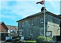
Stonerock House, Hawkhurst High Street
A Grade II listed building, now the Stonerock Dental Clinic.
Image: © Patrick Roper
Taken: 6 May 2022
0.03 miles