IMAGES TAKEN NEAR TO
Frogs Lane, CRANBROOK, TN17 4QB
Introduction
This page details the photographs taken nearby to Frogs Lane, TN17 4QB by members of the Geograph project.
The Geograph project started in 2005 with the aim of publishing, organising and preserving representative images for every square kilometre of Great Britain, Ireland and the Isle of Man.

There are currently over 7.5m images from over14,400 individuals and you can help contribute to the project by visiting https://www.geograph.org.uk
Image Map
Images are licensed for reuse under creativecommons.org/licenses/by-sa/2.0
Notes
- Clicking on the map will re-center to the selected point.
- The higher the marker number, the further away the image location is from the centre of the postcode.
Image Listing (6 Images Found)
Images are licensed for reuse under creativecommons.org/licenses/by-sa/2.0
Image
Details
Distance
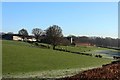
4
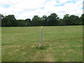
Footpath junction near Cornhill
A footpath from Maytham Road leads past Wildnerness Wood and then straight on towards the A28 Hastings Road. Another footpath heads left towards Frog's Lane past Cornhill House, or right towards Rolvenden.
Image: © David Anstiss
Taken: 7 Jun 2011
0.22 miles
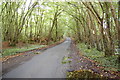
5
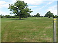
Footpath to Rolvenden
This path leads from Frog's Lane towards Rolvenden.
In the background on the horizon, is St Mary's Church in Rolvenden.
Image: © David Anstiss
Taken: 7 Jun 2011
0.22 miles