IMAGES TAKEN NEAR TO
Mounts Lane, CRANBROOK, TN17 4NN
Introduction
This page details the photographs taken nearby to Mounts Lane, TN17 4NN by members of the Geograph project.
The Geograph project started in 2005 with the aim of publishing, organising and preserving representative images for every square kilometre of Great Britain, Ireland and the Isle of Man.

There are currently over 7.5m images from over14,400 individuals and you can help contribute to the project by visiting https://www.geograph.org.uk
Image Map (Loading...)


Getting Data...Please wait
Leaflet Map data © OpenStreetMap
Images are licensed for reuse under creativecommons.org/licenses/by-sa/2.0
Notes
- Clicking on the map will re-center to the selected point.
- The higher the marker number, the further away the image location is from the centre of the postcode.
Image Listing (77 Images Found)
Images are licensed for reuse under creativecommons.org/licenses/by-sa/2.0
Image
Details
Distance
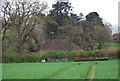
4
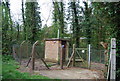
Water monitoring station, Rolvenden Layne
Image: © N Chadwick
Taken: 13 Apr 2011
0.03 miles
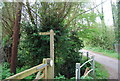
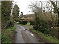
5
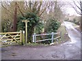
The High Weald Landscape Trail on Mounts Lane
The long distance path heads down the lane towards Rolvenden Layne. It also heads left to cross fields towards Tenterden.
Image: © David Anstiss
Taken: 14 Jan 2010
0.03 miles
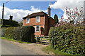
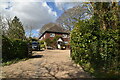
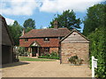
7
Winser Farm Cottage
Cottage as seen from the High Weald Landscape Trail, passing from Rolvenden towards Tenterden.
Image: © David Anstiss
Taken: 7 Jun 2011
0.03 miles
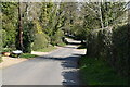
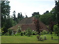
9
Lavender Cottage, Rolvenden Layne
On Mounts Lane.
Image: © David Anstiss
Taken: 7 Jun 2011
0.04 miles