IMAGES TAKEN NEAR TO
Standen Street, CRANBROOK, TN17 4LA
Introduction
This page details the photographs taken nearby to Standen Street, TN17 4LA by members of the Geograph project.
The Geograph project started in 2005 with the aim of publishing, organising and preserving representative images for every square kilometre of Great Britain, Ireland and the Isle of Man.

There are currently over 7.5m images from over14,400 individuals and you can help contribute to the project by visiting https://www.geograph.org.uk
Image Map (Loading...)


Getting Data...Please wait
Leaflet Map data © OpenStreetMap
Images are licensed for reuse under creativecommons.org/licenses/by-sa/2.0
Notes
- Clicking on the map will re-center to the selected point.
- The higher the marker number, the further away the image location is from the centre of the postcode.
Image Listing (27 Images Found)
Images are licensed for reuse under creativecommons.org/licenses/by-sa/2.0
Image
Details
Distance
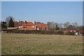
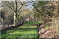
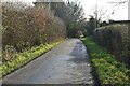
2
Standen street, near Lower Standen Farm
Image: © Julian P Guffogg
Taken: 12 Nov 2011
0.09 miles
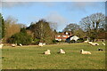
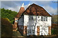
8
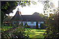
Standen Oast, Standen Street, Iden Green, Kent
Image: © Oast House Archive
Taken: 2 Oct 2008
0.13 miles
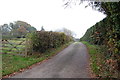
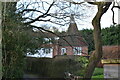
10
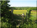
Stile on Standen Road
This stile is at the start of a footpath leading towards Queen Street,Sandhurst.
In the background (on the horizon - in the middle) is Ringle Crouch Green Mill (white windmill).
Image: © David Anstiss
Taken: 23 May 2010
0.15 miles