IMAGES TAKEN NEAR TO
Dingleden, CRANBROOK, TN17 4JU
Introduction
This page details the photographs taken nearby to Dingleden, TN17 4JU by members of the Geograph project.
The Geograph project started in 2005 with the aim of publishing, organising and preserving representative images for every square kilometre of Great Britain, Ireland and the Isle of Man.

There are currently over 7.5m images from over14,400 individuals and you can help contribute to the project by visiting https://www.geograph.org.uk
Image Map
Images are licensed for reuse under creativecommons.org/licenses/by-sa/2.0
Notes
- Clicking on the map will re-center to the selected point.
- The higher the marker number, the further away the image location is from the centre of the postcode.
Image Listing (36 Images Found)
Images are licensed for reuse under creativecommons.org/licenses/by-sa/2.0
Image
Details
Distance
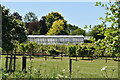
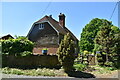
1
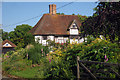
Dingleden House
A very impressive 15th century building.
Image: © Robin Webster
Taken: 5 Apr 2007
0.03 miles
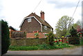
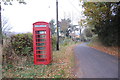
2
Dingleden House, Ramsden lane, Benenden, Kent
Grade II listed.
Image: © Oast House Archive
Taken: 11 Jun 2009
0.04 miles
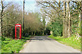

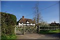
7
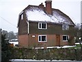
Barn Hill Cottage
On an access road to Dingleden Farm. Also on the High Weald Landscape Trail (long distance footpath), between Benenden and Rolvenden.
Image: © David Anstiss
Taken: 14 Jan 2010
0.14 miles