IMAGES TAKEN NEAR TO
Dingleden, CRANBROOK, TN17 4JT
Introduction
This page details the photographs taken nearby to Dingleden, TN17 4JT by members of the Geograph project.
The Geograph project started in 2005 with the aim of publishing, organising and preserving representative images for every square kilometre of Great Britain, Ireland and the Isle of Man.

There are currently over 7.5m images from over14,400 individuals and you can help contribute to the project by visiting https://www.geograph.org.uk
Image Map (Loading...)


Getting Data...Please wait
Leaflet Map data © OpenStreetMap
Images are licensed for reuse under creativecommons.org/licenses/by-sa/2.0
Notes
- Clicking on the map will re-center to the selected point.
- The higher the marker number, the further away the image location is from the centre of the postcode.
Image Listing (8 Images Found)
Images are licensed for reuse under creativecommons.org/licenses/by-sa/2.0
Image
Details
Distance
1
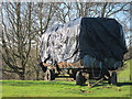
Hay Trailer
A large trailer of hay bales in a field beside Ramsden Lane.
Image: © Oast House Archive
Taken: 8 Feb 2011
0.04 miles
5
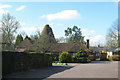
Ranters Oast, Benenden Road, Rolvenden, Kent
Twin round kiln oast house, missing cowls.
Image: © Oast House Archive
Taken: 17 Sep 2006
0.21 miles