IMAGES TAKEN NEAR TO
Swattenden Lane, CRANBROOK, TN17 3PN
Introduction
This page details the photographs taken nearby to Swattenden Lane, TN17 3PN by members of the Geograph project.
The Geograph project started in 2005 with the aim of publishing, organising and preserving representative images for every square kilometre of Great Britain, Ireland and the Isle of Man.

There are currently over 7.5m images from over14,400 individuals and you can help contribute to the project by visiting https://www.geograph.org.uk
Image Map
Images are licensed for reuse under creativecommons.org/licenses/by-sa/2.0
Notes
- Clicking on the map will re-center to the selected point.
- The higher the marker number, the further away the image location is from the centre of the postcode.
Image Listing (13 Images Found)
Images are licensed for reuse under creativecommons.org/licenses/by-sa/2.0
Image
Details
Distance
1
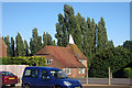
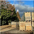
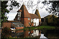
Oast House at Chequer Tree Farm, Swattenden Lane, Cranbrook, Kent
Image: © Oast House Archive
Taken: 7 Aug 2008
0.03 miles
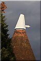
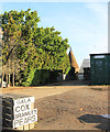
2
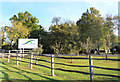
Fridays at Chequertree Farm
A centre of egg production. http://www.fridays.co.uk/our-history/
Image: © Des Blenkinsopp
Taken: 7 Oct 2018
0.06 miles
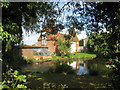
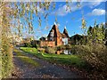
5
Doves Oast, Swattenden Lane, Cranbrook, Kent
Image: © Oast House Archive
Taken: 27 Feb 2008
0.10 miles
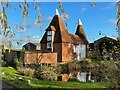
6
Fruit for sale at Doves Farm
The map shows the farm is set in the midst of orchards.
Image: © Des Blenkinsopp
Taken: 7 Oct 2018
0.11 miles