IMAGES TAKEN NEAR TO
Golford, CRANBROOK, TN17 3PB
Introduction
This page details the photographs taken nearby to TN17 3PB by members of the Geograph project.
The Geograph project started in 2005 with the aim of publishing, organising and preserving representative images for every square kilometre of Great Britain, Ireland and the Isle of Man.

There are currently over 7.5m images from over14,400 individuals and you can help contribute to the project by visiting https://www.geograph.org.uk
Image Map
Images are licensed for reuse under creativecommons.org/licenses/by-sa/2.0
Notes
- Clicking on the map will re-center to the selected point.
- The higher the marker number, the further away the image location is from the centre of the postcode.
Image Listing (29 Images Found)
Images are licensed for reuse under creativecommons.org/licenses/by-sa/2.0
Image
Details
Distance
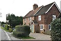
2
High Tilt from the road
As we took the photograph a man appeared and was amazed to learn this square had not been 'snapped'. So was I!
Image: © Steve Benson
Taken: 29 Dec 2007
0.02 miles
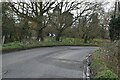
7
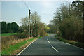
Tenterden Road near High Tilt
The road crosses a tributary of the Crane Brook just past the bend sign, and just past that, on the right, is a private drive to High Tilt.
Image: © Robin Webster
Taken: 22 Mar 2012
0.05 miles