IMAGES TAKEN NEAR TO
Golford Road, CRANBROOK, TN17 3NT
Introduction
This page details the photographs taken nearby to Golford Road, TN17 3NT by members of the Geograph project.
The Geograph project started in 2005 with the aim of publishing, organising and preserving representative images for every square kilometre of Great Britain, Ireland and the Isle of Man.

There are currently over 7.5m images from over14,400 individuals and you can help contribute to the project by visiting https://www.geograph.org.uk
Image Map
Images are licensed for reuse under creativecommons.org/licenses/by-sa/2.0
Notes
- Clicking on the map will re-center to the selected point.
- The higher the marker number, the further away the image location is from the centre of the postcode.
Image Listing (13 Images Found)
Images are licensed for reuse under creativecommons.org/licenses/by-sa/2.0
Image
Details
Distance
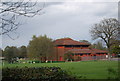
1
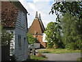
Stream Oast, Golford Road, Cranbrook, Kent
Image: © Oast House Archive
Taken: 13 Aug 2006
0.03 miles
3
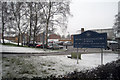
New Buildings at Dulwich School
Built in 2009.
Image: © Oast House Archive
Taken: 8 Feb 2010
0.12 miles
4
Dulwich Prep School, main entrance.
Image: © Jonathan Billinger
Taken: 13 Dec 2006
0.16 miles
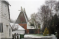
5
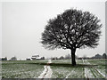
Lone Tree in Snowy Field
On footpath to Coursehorn. Course Horn Oast in distance.
Image: © Oast House Archive
Taken: 8 Feb 2010
0.22 miles
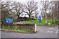
6
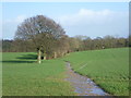
Path near Coursehorne Farm
This is where a footpath from Coursehorne Farm heads towards Golford Road. After weeks of rain, all the paths hereabouts were extremely muddy.
Image: © Marathon
Taken: 1 Feb 2014
0.23 miles
7
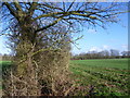
Belt of trees near Coursehorne Farm
A footpath from Coursehorne Farm heads to the right of this belt of trees on its way to Golford Road. A view from a little further back can be seen at http://www.geograph.org.uk/photo/3834407
Image: © Marathon
Taken: 1 Feb 2014
0.23 miles
10
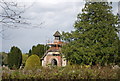
Chapel, Cranbrook Cemetery
St Dunstans Church in Cranbrook closed as a burial ground in 1935. This 4.5 acre site in Golford road was acquired by the Parish council and opened in 1905. The chapel was also built in 1905.
Image: © N Chadwick
Taken: 13 Apr 2011
0.25 miles