IMAGES TAKEN NEAR TO
Oatfield Drive, CRANBROOK, TN17 3NG
Introduction
This page details the photographs taken nearby to Oatfield Drive, TN17 3NG by members of the Geograph project.
The Geograph project started in 2005 with the aim of publishing, organising and preserving representative images for every square kilometre of Great Britain, Ireland and the Isle of Man.

There are currently over 7.5m images from over14,400 individuals and you can help contribute to the project by visiting https://www.geograph.org.uk
Image Map
Images are licensed for reuse under creativecommons.org/licenses/by-sa/2.0
Notes
- Clicking on the map will re-center to the selected point.
- The higher the marker number, the further away the image location is from the centre of the postcode.
Image Listing (316 Images Found)
Images are licensed for reuse under creativecommons.org/licenses/by-sa/2.0
Image
Details
Distance
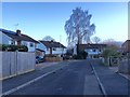
6
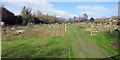
Footpath crosses Wheatfield Way
A public footpath from the High Street to the school goes between the houses in this newer part of Cranbrook.
Image: © Des Blenkinsopp
Taken: 5 Oct 2018
0.08 miles
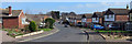
7
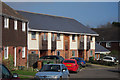
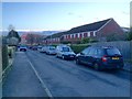
Houses on Hendley Drive
A new block of terraced houses, with brick renders and cedar clad walls and slate roofs.
Image: © Oast House Archive
Taken: 3 Mar 2011
0.09 miles
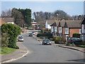
8
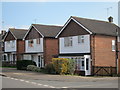
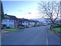
51-55 Oatfield Drive
Three detached houses on Oatfield Drive.
Image: © Oast House Archive
Taken: 3 Mar 2011
0.10 miles