IMAGES TAKEN NEAR TO
The Tanyard, CRANBROOK, TN17 3HX
Introduction
This page details the photographs taken nearby to The Tanyard, TN17 3HX by members of the Geograph project.
The Geograph project started in 2005 with the aim of publishing, organising and preserving representative images for every square kilometre of Great Britain, Ireland and the Isle of Man.

There are currently over 7.5m images from over14,400 individuals and you can help contribute to the project by visiting https://www.geograph.org.uk
Image Map (Loading...)


Getting Data...Please wait
Leaflet Map data © OpenStreetMap
Images are licensed for reuse under creativecommons.org/licenses/by-sa/2.0
Notes
- Clicking on the map will re-center to the selected point.
- The higher the marker number, the further away the image location is from the centre of the postcode.
Image Listing (451 Images Found)
Images are licensed for reuse under creativecommons.org/licenses/by-sa/2.0
Image
Details
Distance

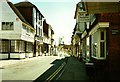
2
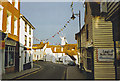
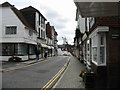
Cranbrook High Street
Kentish village street with weather-boarded houses and old windmill.
Image: © Colin Smith
Taken: Unknown
0.01 miles
3
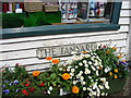
Sign for The Tanyard, a small lane leading from Stone Street
Image: © Nick Smith
Taken: 10 Jul 2008
0.01 miles
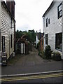
6
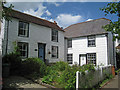
Cranbrook Cottage, and 1 & 2 The Tanyard, Cranrook
Image: © Oast House Archive
Taken: 18 May 2009
0.01 miles
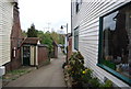
7
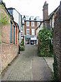
View along The Tanyard onto Stone Street
Image: © Nick Smith
Taken: 10 Jul 2008
0.01 miles
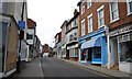
10
Looking SE along Stone Street towards Cranbrook Mill
Image: © Nick Smith
Taken: 10 Jul 2008
0.02 miles