IMAGES TAKEN NEAR TO
St. Davids Bridge, CRANBROOK, TN17 3HJ
Introduction
This page details the photographs taken nearby to St. Davids Bridge, TN17 3HJ by members of the Geograph project.
The Geograph project started in 2005 with the aim of publishing, organising and preserving representative images for every square kilometre of Great Britain, Ireland and the Isle of Man.

There are currently over 7.5m images from over14,400 individuals and you can help contribute to the project by visiting https://www.geograph.org.uk
Image Map (Loading...)


Getting Data...Please wait
Leaflet Map data © OpenStreetMap
Images are licensed for reuse under creativecommons.org/licenses/by-sa/2.0
Notes
- Clicking on the map will re-center to the selected point.
- The higher the marker number, the further away the image location is from the centre of the postcode.
Image Listing (441 Images Found)
Images are licensed for reuse under creativecommons.org/licenses/by-sa/2.0
Image
Details
Distance
2
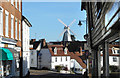
Union Mill above the rooftops
Cranbrook's Union Windmill was built at a later date than many of the surrounding buildings so a tall tower was needed to get the sails up above their shelter and into the wind.
Image: © Des Blenkinsopp
Taken: 5 Oct 2018
0.01 miles
4
Looking SW along Waterloo Road, Cranbrook
Image: © Nick Smith
Taken: 10 Jul 2008
0.01 miles
5
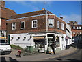
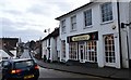
Waterloo House Tearooms
Formerly a lighting shop and now a tearoom. On Waterloo Road at junction with Stone Street and The Hill.
Image: © Oast House Archive
Taken: 3 Mar 2011
0.01 miles
7
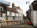
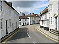
Waterloo Road, Cranbrook
The road has been worked on for much of the year, and has been closed for a number of weeks. At the junction with St Johns Bridge.
Image: © Oast House Archive
Taken: 15 Apr 2010
0.01 miles
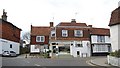
8
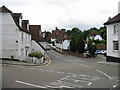
View of the junction on The Hill and Waterloo Road
Taken from Stone Street looking towards Waterloo Road on the left and The Hill off to the right.
Image: © Nick Smith
Taken: 10 Jul 2008
0.01 miles
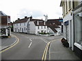
9
The Hill from Stone Street
Difficult to place accurately from the 1:50,000 Modern Day Landranger™ Map
Image: © Nick Smith
Taken: 10 Jul 2008
0.01 miles
10
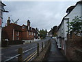
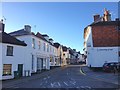
The Hill, Cranbrook
Walking up The Hill en route to the windmill, whose sails can be seen behind the houses to the left.
Image: © Barbara Carr
Taken: 26 Sep 2010
0.01 miles