IMAGES TAKEN NEAR TO
High Street, CRANBROOK, TN17 3EB
Introduction
This page details the photographs taken nearby to High Street, TN17 3EB by members of the Geograph project.
The Geograph project started in 2005 with the aim of publishing, organising and preserving representative images for every square kilometre of Great Britain, Ireland and the Isle of Man.

There are currently over 7.5m images from over14,400 individuals and you can help contribute to the project by visiting https://www.geograph.org.uk
Image Map (Loading...)


Getting Data...Please wait
Leaflet Map data © OpenStreetMap
Images are licensed for reuse under creativecommons.org/licenses/by-sa/2.0
Notes
- Clicking on the map will re-center to the selected point.
- The higher the marker number, the further away the image location is from the centre of the postcode.
Image Listing (465 Images Found)
Images are licensed for reuse under creativecommons.org/licenses/by-sa/2.0
Image
Details
Distance
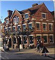
3
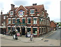
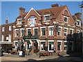
The White Horse, Cranbrook
A Greene King house.
Image: © Robin Webster
Taken: 16 Feb 2014
0.00 miles
4
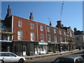
Shops on High Street, Cranbrook, Kent
Grade II listed.
Image: © Oast House Archive
Taken: 2 Jun 2009
0.01 miles
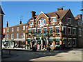
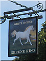
5
White Horse, Cranbrook
A Greene King pub on High Street, at junction with Carrier's Road.
Image: © Oast House Archive
Taken: 3 Sep 2010
0.01 miles
6
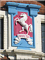
Invicta on the White Horse
An Invicta emblem on the wall of Image
Image: © Oast House Archive
Taken: 3 Sep 2010
0.01 miles
10
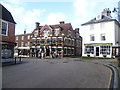
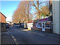
The centre of Cranbrook
Cranbrook is the only considerable market town in Kent which grew up entirely through trade. It was once a headquarters of the iron-smelting of the forests of the Weald but its real prosperity came with cloth, a trade which started in the 13th century. By Tudor times Cranbrook had a population of 3,000 when Maidstone had a population of only 2,000. The cloth trade declined after the 16th century but Cranbrook remained busy.
The centre of Cranbrook is where Stone Street, Carriers Road and High Street meet, just down from St Dunstan's Church. In this view from Stone Street, Carriers Road is to the right of the White Horse and High Street is to the left.
Image: © Marathon
Taken: 1 Feb 2014
0.01 miles