IMAGES TAKEN NEAR TO
Rope Walk, CRANBROOK, TN17 3DZ
Introduction
This page details the photographs taken nearby to Rope Walk, TN17 3DZ by members of the Geograph project.
The Geograph project started in 2005 with the aim of publishing, organising and preserving representative images for every square kilometre of Great Britain, Ireland and the Isle of Man.

There are currently over 7.5m images from over14,400 individuals and you can help contribute to the project by visiting https://www.geograph.org.uk
Image Map (Loading...)


Getting Data...Please wait
Leaflet Map data © OpenStreetMap
Images are licensed for reuse under creativecommons.org/licenses/by-sa/2.0
Notes
- Clicking on the map will re-center to the selected point.
- The higher the marker number, the further away the image location is from the centre of the postcode.
Image Listing (401 Images Found)
Images are licensed for reuse under creativecommons.org/licenses/by-sa/2.0
Image
Details
Distance
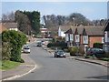
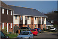
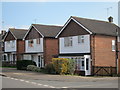
1
Rope Walk
Semi detached houses on Rope Walk.
Image: © Oast House Archive
Taken: 3 Mar 2011
0.01 miles
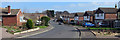
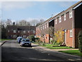
2
Houses on Hendley Drive
A new block of terraced houses, with brick renders and cedar clad walls and slate roofs.
Image: © Oast House Archive
Taken: 3 Mar 2011
0.02 miles
5
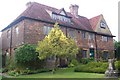
Cranbrook Museum
On Carriers Road. Housed in a restored 15th Century Building, which charts the history of the region from early Roman settlements to the present day. The commercial and social life of Cranbrook is richly illustrated with a collection of artefacts ranging from important relics to modest ephemera. The valuable archives are available to ancestral research.
Image: © David Anstiss
Taken: 20 Sep 2009
0.04 miles
6
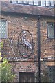
Sign over Cranbrook Museum front door
This sign relates to the 'crane brook' after which the town is named…
The place name Cranbrook derives from Old English cran broc, meaning Crane Marsh, marshy ground frequented by cranes (although more probably herons). http://en.wikipedia.org/wiki/Cranbrook,_Kent
Image: © David Anstiss
Taken: 20 Sep 2009
0.05 miles
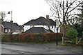
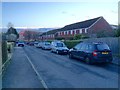
7
51-55 Oatfield Drive
Three detached houses on Oatfield Drive.
Image: © Oast House Archive
Taken: 3 Mar 2011
0.05 miles