IMAGES TAKEN NEAR TO
High Street, CRANBROOK, TN17 3DF
Introduction
This page details the photographs taken nearby to High Street, TN17 3DF by members of the Geograph project.
The Geograph project started in 2005 with the aim of publishing, organising and preserving representative images for every square kilometre of Great Britain, Ireland and the Isle of Man.

There are currently over 7.5m images from over14,400 individuals and you can help contribute to the project by visiting https://www.geograph.org.uk
Image Map (Loading...)


Getting Data...Please wait
Leaflet Map data © OpenStreetMap
Images are licensed for reuse under creativecommons.org/licenses/by-sa/2.0
Notes
- Clicking on the map will re-center to the selected point.
- The higher the marker number, the further away the image location is from the centre of the postcode.
Image Listing (462 Images Found)
Images are licensed for reuse under creativecommons.org/licenses/by-sa/2.0
Image
Details
Distance
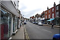
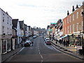
1
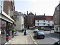
Cranbrook High Street
On the left is Carriers Road and the High Street turns the corner into Stone Street
Image: © Nick Smith
Taken: 10 Jul 2008
0.00 miles
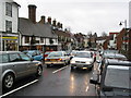
3
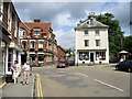
Junction of Stone Street with High Street and Carrier Road
Image: © Nick Smith
Taken: 10 Jul 2008
0.01 miles
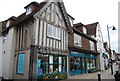
4
The White Horse Public House, High Street, Cranbrook, Kent
Image: © Oast House Archive
Taken: 2 Jun 2009
0.01 miles
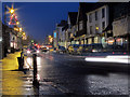
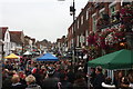
6
Nearly Xmas
High Street in festive mood on a gloomy winter's day.
Image: © Peter Turner
Taken: 29 Nov 2003
0.01 miles
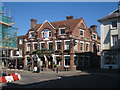
7
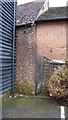
Possibly 15 century brickwork to the rear of the George Inn Cranbrook Kent
Image: © Peter Skynner
Taken: 14 Feb 2015
0.02 miles
10
Cranbrook Apple Fair, High Street
Image: © Oast House Archive
Taken: 6 Oct 2018
0.02 miles