IMAGES TAKEN NEAR TO
Bedgebury Road, CRANBROOK, TN17 2SJ
Introduction
This page details the photographs taken nearby to Bedgebury Road, TN17 2SJ by members of the Geograph project.
The Geograph project started in 2005 with the aim of publishing, organising and preserving representative images for every square kilometre of Great Britain, Ireland and the Isle of Man.

There are currently over 7.5m images from over14,400 individuals and you can help contribute to the project by visiting https://www.geograph.org.uk
Image Map (Loading...)


Getting Data...Please wait
Leaflet Map data © OpenStreetMap
Images are licensed for reuse under creativecommons.org/licenses/by-sa/2.0
Notes
- Clicking on the map will re-center to the selected point.
- The higher the marker number, the further away the image location is from the centre of the postcode.
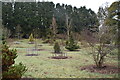
Image Listing (45 Images Found)
Images are licensed for reuse under creativecommons.org/licenses/by-sa/2.0
Image
Details
Distance
4
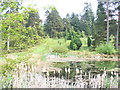
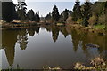
Lake in Bedgebury Pinetum
Bulrushes fringe the lake. The slopes around the pond have a variety of specimen conifers.
Image: © Colin Smith
Taken: 10 May 2008
0.16 miles
6
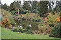
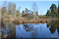
Marshal's Lake at Bedgebury
The lowest lake in that part of the valley within the Forestry Commission's land.
Image: © David M Clark
Taken: 4 Nov 2022
0.17 miles
8
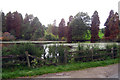
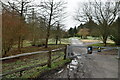
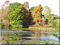
Marshal's Lake, Bedgebury Pinetum, Goudhurst, Kent
Image: © Oast House Archive
Taken: 11 Nov 2006
0.18 miles