IMAGES TAKEN NEAR TO
Church Road, CRANBROOK, TN17 2SF
Introduction
This page details the photographs taken nearby to Church Road, TN17 2SF by members of the Geograph project.
The Geograph project started in 2005 with the aim of publishing, organising and preserving representative images for every square kilometre of Great Britain, Ireland and the Isle of Man.

There are currently over 7.5m images from over14,400 individuals and you can help contribute to the project by visiting https://www.geograph.org.uk
Image Map
Images are licensed for reuse under creativecommons.org/licenses/by-sa/2.0
Notes
- Clicking on the map will re-center to the selected point.
- The higher the marker number, the further away the image location is from the centre of the postcode.
Image Listing (115 Images Found)
Images are licensed for reuse under creativecommons.org/licenses/by-sa/2.0
Image
Details
Distance
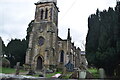
3
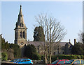
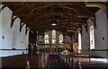
Christ Church in Kilndown, Kent
Christ Church in Kilndown, Kent
Image: © John P Reeves
Taken: 13 Nov 2016
0.02 miles
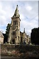
4
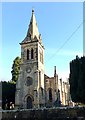
Christ Church in Kilndown, Kent
Christ Church in Kilndown, Kent viewed distantly from Church Road.
Image: © John P Reeves
Taken: 13 Nov 2016
0.02 miles
6
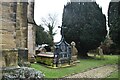
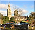
Tomb of AJ Beresford Hope, Kilndown
Grade II listed.
Image: © N Chadwick
Taken: 11 Jan 2021
0.02 miles
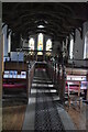
10
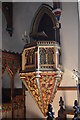
Pulpit, Christchurch, Kilndown
The preacher is several metres above the floor.
Image: © Julian P Guffogg
Taken: 30 Jun 2013
0.02 miles