IMAGES TAKEN NEAR TO
Church Road, CRANBROOK, TN17 2RY
Introduction
This page details the photographs taken nearby to Church Road, TN17 2RY by members of the Geograph project.
The Geograph project started in 2005 with the aim of publishing, organising and preserving representative images for every square kilometre of Great Britain, Ireland and the Isle of Man.

There are currently over 7.5m images from over14,400 individuals and you can help contribute to the project by visiting https://www.geograph.org.uk
Image Map (Loading...)


Getting Data...Please wait
Leaflet Map data © OpenStreetMap
Images are licensed for reuse under creativecommons.org/licenses/by-sa/2.0
Notes
- Clicking on the map will re-center to the selected point.
- The higher the marker number, the further away the image location is from the centre of the postcode.
Image Listing (127 Images Found)
Images are licensed for reuse under creativecommons.org/licenses/by-sa/2.0
Image
Details
Distance
5
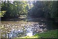
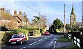
Kilndown Pond
Behind the Quarry Centre. Beside the footpath from Church Road to the A21, near Bewlbridge.
Image: © David Anstiss
Taken: 27 Sep 2009
0.03 miles
6
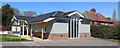
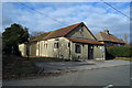
Kilndown village hall
New hall replacing Image, and clad in fibre cement weatherboard.
Image: © Oast House Archive
Taken: 12 Apr 2015
0.03 miles
7
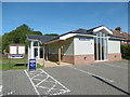
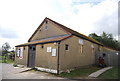
Kilndown Village Hall
Kilndown Village Hall was built as recently as 2010. For more information see https://www.hallshire.com/halls/view/810/kilndown-village-hall
Image: © Marathon
Taken: 11 Sep 2016
0.03 miles
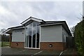
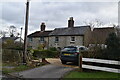
10

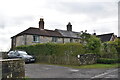
Cottages, Church St
Stone built terrace of cottages near the church.
Image: © N Chadwick
Taken: 21 Mar 2010
0.04 miles