IMAGES TAKEN NEAR TO
Whitewell Lane, CRANBROOK, TN17 2PP
Introduction
This page details the photographs taken nearby to Whitewell Lane, TN17 2PP by members of the Geograph project.
The Geograph project started in 2005 with the aim of publishing, organising and preserving representative images for every square kilometre of Great Britain, Ireland and the Isle of Man.

There are currently over 7.5m images from over14,400 individuals and you can help contribute to the project by visiting https://www.geograph.org.uk
Image Map (Loading...)


Getting Data...Please wait
Leaflet Map data © OpenStreetMap
Images are licensed for reuse under creativecommons.org/licenses/by-sa/2.0
Notes
- Clicking on the map will re-center to the selected point.
- The higher the marker number, the further away the image location is from the centre of the postcode.
Image Listing (23 Images Found)
Images are licensed for reuse under creativecommons.org/licenses/by-sa/2.0
Image
Details
Distance

6
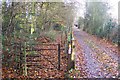
Kissing Gate near Fir House
A footpath from the A229 Angley Road heads along a driveway to Fir House. Then heads through kissing gate towards Gravel Pit Wood.
Image: © David Anstiss
Taken: 22 Nov 2009
0.20 miles
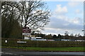
9

No more a kissing Gate near Rock Wood
This gate was on a path from the A229 Angley Road towards Gravel Pit Wood.
Image: © David Anstiss
Taken: 22 Nov 2009
0.21 miles
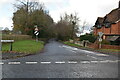
10

Oak Cottages
Grade II listed. https://historicengland.org.uk/listing/the-list/list-entry/1084792
Image: © N Chadwick
Taken: 5 Dec 2020
0.21 miles