IMAGES TAKEN NEAR TO
Cranbrook Road, CRANBROOK, TN17 2NX
Introduction
This page details the photographs taken nearby to Cranbrook Road, TN17 2NX by members of the Geograph project.
The Geograph project started in 2005 with the aim of publishing, organising and preserving representative images for every square kilometre of Great Britain, Ireland and the Isle of Man.

There are currently over 7.5m images from over14,400 individuals and you can help contribute to the project by visiting https://www.geograph.org.uk
Image Map
Images are licensed for reuse under creativecommons.org/licenses/by-sa/2.0
Notes
- Clicking on the map will re-center to the selected point.
- The higher the marker number, the further away the image location is from the centre of the postcode.
Image Listing (30 Images Found)
Images are licensed for reuse under creativecommons.org/licenses/by-sa/2.0
Image
Details
Distance
8
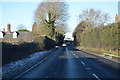
Mile Lane meets Cranbrook Road
The A262 Cranbrook Road heads straight on towards Four Wents and Sissinghurst, from Goudhurst. Mile Lane on the left heads towards Jarvis Lane.
Image: © David Anstiss
Taken: 22 Nov 2009
0.09 miles
9
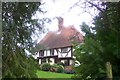
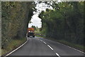
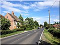
Chequer Tree Farmhouse
As seen from a footpath from Mile Lane, Iden Green towards Old Park Woods.
Image: © David Anstiss
Taken: 22 Nov 2009
0.09 miles
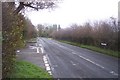
10
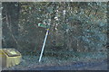
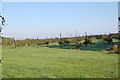
A reclining footpath signpost, Mill Lane
Image: © N Chadwick
Taken: 3 Feb 2019
0.09 miles