IMAGES TAKEN NEAR TO
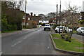
Common Road, CRANBROOK, TN17 2JR
Introduction
This page details the photographs taken nearby to Common Road, TN17 2JR by members of the Geograph project.
The Geograph project started in 2005 with the aim of publishing, organising and preserving representative images for every square kilometre of Great Britain, Ireland and the Isle of Man.

There are currently over 7.5m images from over14,400 individuals and you can help contribute to the project by visiting https://www.geograph.org.uk
Image Map (Loading...)


Getting Data...Please wait
Leaflet Map data © OpenStreetMap
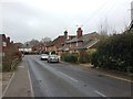
Images are licensed for reuse under creativecommons.org/licenses/by-sa/2.0
Notes
- Clicking on the map will re-center to the selected point.
- The higher the marker number, the further away the image location is from the centre of the postcode.
Image Listing (151 Images Found)
Images are licensed for reuse under creativecommons.org/licenses/by-sa/2.0
Image
Details
Distance
3
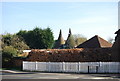
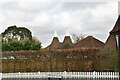
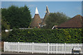
The Oast house, Collins Farm, Sissinghurst
Image: © N Chadwick
Taken: 10 Apr 2010
0.02 miles
5
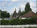
Collins Farm Oast, Common Road, Sissinghurst, Kent
Image: © Oast House Archive
Taken: 8 Sep 2009
0.03 miles
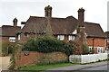
8
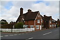
The Cottage and April Cottage
Grade II listed. https://historicengland.org.uk/listing/the-list/list-entry/1067782
Image: © N Chadwick
Taken: 18 Mar 2020
0.03 miles
9
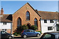
The old Wesleyan Chapel, Sissinghurst
Built in 1869, now converted to a residence.
Image: © N Chadwick
Taken: 10 Apr 2010
0.03 miles
10
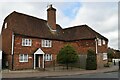
Kings Head House
Grade II* listed. https://historicengland.org.uk/listing/the-list/list-entry/1084814
Image: © N Chadwick
Taken: 18 Mar 2020
0.03 miles