IMAGES TAKEN NEAR TO
The Common, CRANBROOK, TN17 2HU
Introduction
This page details the photographs taken nearby to The Common, TN17 2HU by members of the Geograph project.
The Geograph project started in 2005 with the aim of publishing, organising and preserving representative images for every square kilometre of Great Britain, Ireland and the Isle of Man.

There are currently over 7.5m images from over14,400 individuals and you can help contribute to the project by visiting https://www.geograph.org.uk
Image Map
Images are licensed for reuse under creativecommons.org/licenses/by-sa/2.0
Notes
- Clicking on the map will re-center to the selected point.
- The higher the marker number, the further away the image location is from the centre of the postcode.
Image Listing (37 Images Found)
Images are licensed for reuse under creativecommons.org/licenses/by-sa/2.0
Image
Details
Distance
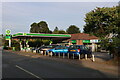
2
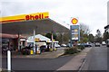
Shell filling station on the A229 near Cranbrook.
Image: © Jonathan Billinger
Taken: 13 Dec 2006
0.11 miles
3
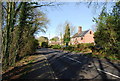
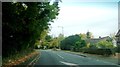
Cranbrook, Sissinghurst Road
Cranbrook, Sissinghurst Road, A262.
Image: © Helmut Zozmann
Taken: 31 Jul 2011
0.11 miles
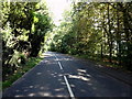
4
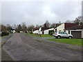
The Street (A262), west of Sissinghurst (2)
Image: © N Chadwick
Taken: 10 Apr 2010
0.11 miles
5
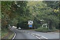
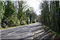
A262 (Sissinghurst Road) approaching junction with A229
Image: © Clint Mann
Taken: 30 Oct 2015
0.12 miles
7
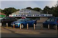
Ashwal MOT Centre on the A229, Wilsley Pound
Image: © David Howard
Taken: 28 Aug 2022
0.15 miles
8
Petrol station on the A229, Wilsley Pound
This was Shell last year.
Image: © David Howard
Taken: 28 Aug 2022
0.15 miles
9
Cranbrook, Sissinghurst Road
Cranbrook, Sissinghurst Road, A262.
Image: © Helmut Zozmann
Taken: 31 Jul 2011
0.16 miles