IMAGES TAKEN NEAR TO
Frittenden, CRANBROOK, TN17 2DB
Introduction
This page details the photographs taken nearby to TN17 2DB by members of the Geograph project.
The Geograph project started in 2005 with the aim of publishing, organising and preserving representative images for every square kilometre of Great Britain, Ireland and the Isle of Man.

There are currently over 7.5m images from over14,400 individuals and you can help contribute to the project by visiting https://www.geograph.org.uk
Image Map (Loading...)


Getting Data...Please wait
Leaflet Map data © OpenStreetMap
Images are licensed for reuse under creativecommons.org/licenses/by-sa/2.0
Notes
- Clicking on the map will re-center to the selected point.
- The higher the marker number, the further away the image location is from the centre of the postcode.
Image Listing (13 Images Found)
Images are licensed for reuse under creativecommons.org/licenses/by-sa/2.0
Image
Details
Distance
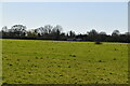
1
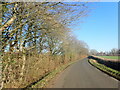
Cranbrook Road
This is Cranbrook Road on an icy January day looking towards Frittenden.
Image: © Marathon
Taken: 21 Jan 2023
0.14 miles
2
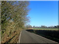
Cranbrook Road
This is Cranbrook Road on an icy January day looking towards Frittenden.
Image: © Marathon
Taken: 21 Jan 2023
0.15 miles
3
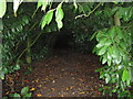
Footpath into Leggs Wood
This path leads from Mill Lane. The wood at this part is mostly Rhododendrons. Hence reason why path is so dark. Note, also overgrown so have to 'stoop' to go into wood.
Image: © David Anstiss
Taken: 5 Jul 2009
0.15 miles
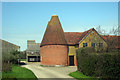
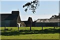
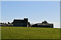
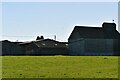
6
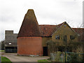
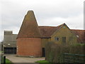
Oast House at Parsonage Farm, Cranbrook Road, Frittenden
Image: © Oast House Archive
Taken: 22 Mar 2015
0.22 miles