IMAGES TAKEN NEAR TO
Cranbrook Road, CRANBROOK, TN17 2BW
Introduction
This page details the photographs taken nearby to Cranbrook Road, TN17 2BW by members of the Geograph project.
The Geograph project started in 2005 with the aim of publishing, organising and preserving representative images for every square kilometre of Great Britain, Ireland and the Isle of Man.

There are currently over 7.5m images from over14,400 individuals and you can help contribute to the project by visiting https://www.geograph.org.uk
Image Map (Loading...)


Getting Data...Please wait
Leaflet Map data © OpenStreetMap
Images are licensed for reuse under creativecommons.org/licenses/by-sa/2.0
Notes
- Clicking on the map will re-center to the selected point.
- The higher the marker number, the further away the image location is from the centre of the postcode.
Image Listing (11 Images Found)
Images are licensed for reuse under creativecommons.org/licenses/by-sa/2.0
Image
Details
Distance
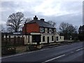
2
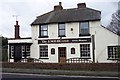
The Knoxbridge Inn
By the A229 south of Staplehurst.
Image: © Jonathan Billinger
Taken: 13 Dec 2006
0.17 miles
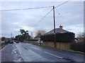
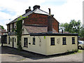
5
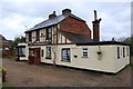
The Hop Bine pub on A229 at Knox Bridge
Image: © Julian P Guffogg
Taken: 28 Apr 2012
0.19 miles
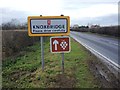
7
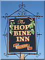
The Hop Bine Inn sign
Until the late 2000s the pub was called the Knoxbridge Inn. Image
Image: © Oast House Archive
Taken: 25 Oct 2010
0.20 miles