IMAGES TAKEN NEAR TO
Camden Hill, CRANBROOK, TN17 2AS
Introduction
This page details the photographs taken nearby to Camden Hill, TN17 2AS by members of the Geograph project.
The Geograph project started in 2005 with the aim of publishing, organising and preserving representative images for every square kilometre of Great Britain, Ireland and the Isle of Man.

There are currently over 7.5m images from over14,400 individuals and you can help contribute to the project by visiting https://www.geograph.org.uk
Image Map (Loading...)


Getting Data...Please wait
Leaflet Map data © OpenStreetMap
Images are licensed for reuse under creativecommons.org/licenses/by-sa/2.0
Notes
- Clicking on the map will re-center to the selected point.
- The higher the marker number, the further away the image location is from the centre of the postcode.
Image Listing (27 Images Found)
Images are licensed for reuse under creativecommons.org/licenses/by-sa/2.0
Image
Details
Distance
1
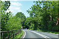
A229 heading north
Towards Staplehurst.
Image: © Robin Webster
Taken: 28 May 2018
0.03 miles
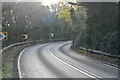
4

Rocks Hill, Cranbrook Common, Kent
Bend in road between Staplehurst and Cranbrook.
Image: © Oast House Archive
Taken: 16 Oct 2008
0.07 miles
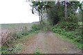
6
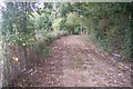
Track to Foxearth Wood
This track leads from the A229 Rock's Hill towards the wood. A footpath to Frittenden Road also uses some of the track.
Image: © David Anstiss
Taken: 20 Sep 2009
0.10 miles
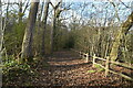
9
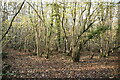
Footpath in Foxearth Wood
This path leads from the A229 Rock's Hill to Frittenden Road. Normally path markers are yellow, and bridleway markers are red. But this path was marked with red poles.
Image: © David Anstiss
Taken: 20 Sep 2009
0.12 miles
10
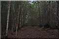
Track to Foxearth Wood, off Rocks Hill
Also a Public Footpath
Image: © Julian P Guffogg
Taken: 28 Apr 2012
0.12 miles