IMAGES TAKEN NEAR TO
Summerhill, CRANBROOK, TN17 1JU
Introduction
This page details the photographs taken nearby to Summerhill, TN17 1JU by members of the Geograph project.
The Geograph project started in 2005 with the aim of publishing, organising and preserving representative images for every square kilometre of Great Britain, Ireland and the Isle of Man.

There are currently over 7.5m images from over14,400 individuals and you can help contribute to the project by visiting https://www.geograph.org.uk
Image Map (Loading...)


Getting Data...Please wait
Leaflet Map data © OpenStreetMap
Images are licensed for reuse under creativecommons.org/licenses/by-sa/2.0
Notes
- Clicking on the map will re-center to the selected point.
- The higher the marker number, the further away the image location is from the centre of the postcode.
Image Listing (19 Images Found)
Images are licensed for reuse under creativecommons.org/licenses/by-sa/2.0
Image
Details
Distance
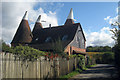
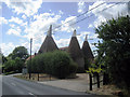
2
Harpers Oast
The 2 other roundels are not seen in this view.
Image: © Julian P Guffogg
Taken: 11 Sep 2012
0.05 miles
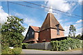
4
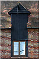
Former Hoist at Harpers Farm Oast
Hoists were built into many later oast houses, to lift the large hop pockets onto the carts or lorry. Unusually this hoist was in the kiln.
Main building Image
Image: © Oast House Archive
Taken: 30 Jul 2006
0.05 miles