IMAGES TAKEN NEAR TO
North Road, CRANBROOK, TN17 1JJ
Introduction
This page details the photographs taken nearby to North Road, TN17 1JJ by members of the Geograph project.
The Geograph project started in 2005 with the aim of publishing, organising and preserving representative images for every square kilometre of Great Britain, Ireland and the Isle of Man.

There are currently over 7.5m images from over14,400 individuals and you can help contribute to the project by visiting https://www.geograph.org.uk
Image Map (Loading...)


Getting Data...Please wait
Leaflet Map data © OpenStreetMap
Images are licensed for reuse under creativecommons.org/licenses/by-sa/2.0
Notes
- Clicking on the map will re-center to the selected point.
- The higher the marker number, the further away the image location is from the centre of the postcode.
Image Listing (10 Images Found)
Images are licensed for reuse under creativecommons.org/licenses/by-sa/2.0
Image
Details
Distance
7
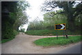
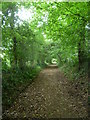
Footpath towards Brandfold
This is path (No.WC22) leading toward North Road, from Share Farm and Brick Kiln Lane.
Image: © David Anstiss
Taken: 26 Sep 2009
0.23 miles
8
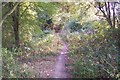
Footpath leading away from North Road
This footpath (which is shown on the map as a track) eventually reaches Trottenden Farm and the High Weald Landscape Trail or Share Farm across the River Teise.
Image: © Marathon
Taken: 22 Jun 2013
0.24 miles
9
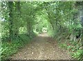
Footpath near Brandfold
This footpath (which is shown on the map as a track) eventually reaches Trottenden Farm and the High Weald Landscape Trail or Share Farm across the River Teise.
Image: © Marathon
Taken: 22 Jun 2013
0.24 miles
10
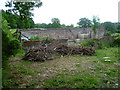
An old barn
Looking at the aerial view, it appears this barn recently had a roof which it has now lost. It is still used for storage as can be seen here from the adjacent footpath.
Image: © Marathon
Taken: 22 Jun 2013
0.24 miles