IMAGES TAKEN NEAR TO
Cranbrook Road, CRANBROOK, TN17 1DS
Introduction
This page details the photographs taken nearby to Cranbrook Road, TN17 1DS by members of the Geograph project.
The Geograph project started in 2005 with the aim of publishing, organising and preserving representative images for every square kilometre of Great Britain, Ireland and the Isle of Man.

There are currently over 7.5m images from over14,400 individuals and you can help contribute to the project by visiting https://www.geograph.org.uk
Image Map
Images are licensed for reuse under creativecommons.org/licenses/by-sa/2.0
Notes
- Clicking on the map will re-center to the selected point.
- The higher the marker number, the further away the image location is from the centre of the postcode.
Image Listing (35 Images Found)
Images are licensed for reuse under creativecommons.org/licenses/by-sa/2.0
Image
Details
Distance
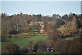
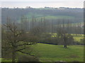
5
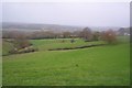
View from Maypole Lane
View looking southwards across Maypole Farm.
Image: © David Anstiss
Taken: 22 Nov 2009
0.15 miles
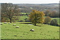
7
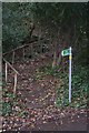
Steps on Maypole Lane
These steps lead up to Back Lane in Goudhurst.
Image: © David Anstiss
Taken: 22 Nov 2009
0.18 miles
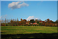
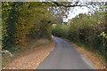
8
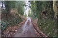
Maypole Lane
This lane leads from the A262 Cranbrook Road, down to the B2079 Balcombes Hill.
Image: © David Anstiss
Taken: 22 Nov 2009
0.20 miles
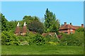
10
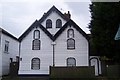
1 and 2 Holly Villas
On the A262 Cranbrook Road, opposite the Chequers Inn Car Park.
Note, the statues in the alcoves above the second floor windows.
Image: © David Anstiss
Taken: 22 Nov 2009
0.20 miles