IMAGES TAKEN NEAR TO
Chequers Road, CRANBROOK, TN17 1DH
Introduction
This page details the photographs taken nearby to Chequers Road, TN17 1DH by members of the Geograph project.
The Geograph project started in 2005 with the aim of publishing, organising and preserving representative images for every square kilometre of Great Britain, Ireland and the Isle of Man.

There are currently over 7.5m images from over14,400 individuals and you can help contribute to the project by visiting https://www.geograph.org.uk
Image Map (Loading...)


Getting Data...Please wait
Leaflet Map data © OpenStreetMap
Images are licensed for reuse under creativecommons.org/licenses/by-sa/2.0
Notes
- Clicking on the map will re-center to the selected point.
- The higher the marker number, the further away the image location is from the centre of the postcode.
Image Listing (43 Images Found)
Images are licensed for reuse under creativecommons.org/licenses/by-sa/2.0
Image
Details
Distance

3

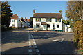
Wealden Hall House on Chequers Lane, Goudhurst, Kent
Grade II listed.
Image: © Oast House Archive
Taken: 6 Aug 2009
0.06 miles
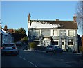
7
The Chequers Inn, Goudhurst
Was closed at the time. Has subsequently been reopened.
Image: © Julian P Guffogg
Taken: 16 Oct 2011
0.09 miles
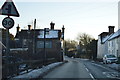
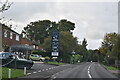
10
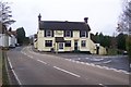
The Chequers Inn, Goudhurst
On the junction on the A262 Cranbrook Road on the left and the B2084 on the right.
Image: © David Anstiss
Taken: 22 Nov 2009
0.09 miles