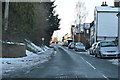
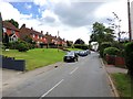
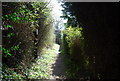
IMAGES TAKEN NEAR TO
North Road, CRANBROOK, TN17 1AS
Introduction
This page details the photographs taken nearby to North Road, TN17 1AS by members of the Geograph project.
The Geograph project started in 2005 with the aim of publishing, organising and preserving representative images for every square kilometre of Great Britain, Ireland and the Isle of Man.

There are currently over 7.5m images from over14,400 individuals and you can help contribute to the project by visiting https://www.geograph.org.uk
Image Map (Loading...)


Getting Data...Please wait
Leaflet Map data © OpenStreetMap
Images are licensed for reuse under creativecommons.org/licenses/by-sa/2.0
Notes
- Clicking on the map will re-center to the selected point.
- The higher the marker number, the further away the image location is from the centre of the postcode.
Image Listing (365 Images Found)
Images are licensed for reuse under creativecommons.org/licenses/by-sa/2.0
Image
Details
Distance
3
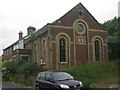
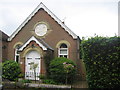
Disused Wesleyan Chapel
On North Road in Goudhurst. Built in 1878.
Image: © David Anstiss
Taken: 3 Jun 2009
0.04 miles
6
Chapel House
Converted Chapel on Beresford Road.
Image: © David Anstiss
Taken: 3 Jun 2009
0.06 miles
8
Goudhurst House
Grade II listed. https://historicengland.org.uk/listing/the-list/list-entry/1084672
Image: © N Chadwick
Taken: 3 Feb 2019
0.08 miles
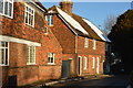
9
Church House, High St
Tile hung building.
Image: © N Chadwick
Taken: 10 Apr 2010
0.08 miles
10
Church House, Goudhurst: early August 2015
Image: © Basher Eyre
Taken: 8 Aug 2015
0.08 miles