IMAGES TAKEN NEAR TO
West Road, CRANBROOK, TN17 1AB
Introduction
This page details the photographs taken nearby to West Road, TN17 1AB by members of the Geograph project.
The Geograph project started in 2005 with the aim of publishing, organising and preserving representative images for every square kilometre of Great Britain, Ireland and the Isle of Man.

There are currently over 7.5m images from over14,400 individuals and you can help contribute to the project by visiting https://www.geograph.org.uk
Image Map (Loading...)


Getting Data...Please wait
Leaflet Map data © OpenStreetMap
Images are licensed for reuse under creativecommons.org/licenses/by-sa/2.0
Notes
- Clicking on the map will re-center to the selected point.
- The higher the marker number, the further away the image location is from the centre of the postcode.
Image Listing (388 Images Found)
Images are licensed for reuse under creativecommons.org/licenses/by-sa/2.0
Image
Details
Distance
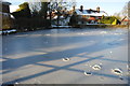
2
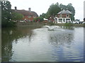
Hughenden across the Pond
Grade II listed. https://historicengland.org.uk/listing/the-list/list-entry/1104936
Image: © N Chadwick
Taken: 3 Feb 2019
0.01 miles
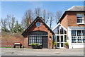
3
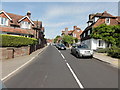
Goudhurst
Goudhurst, West Road, A262
Image: © Helmut Zozmann
Taken: 31 Jul 2011
0.01 miles
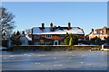
4
Goudhurst Pond
The village pond has a modern pumped fountain at its centre.
Image: © Graham Hale
Taken: 10 Aug 2013
0.01 miles
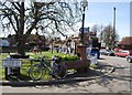
5
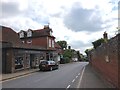
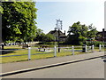
Goudhurst Village Sign
On a green on West Road, beside the village pond.
Image: © David Anstiss
Taken: 3 May 2009
0.01 miles
7
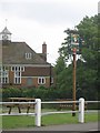
Goudhurst
Goudhurst, Village Duck Pond.
Image: © Helmut Zozmann
Taken: 31 Jul 2011
0.02 miles