IMAGES TAKEN NEAR TO
Clarks Lane, WESTERHAM, TN16 2JU
Introduction
This page details the photographs taken nearby to Clarks Lane, TN16 2JU by members of the Geograph project.
The Geograph project started in 2005 with the aim of publishing, organising and preserving representative images for every square kilometre of Great Britain, Ireland and the Isle of Man.

There are currently over 7.5m images from over14,400 individuals and you can help contribute to the project by visiting https://www.geograph.org.uk
Image Map (Loading...)


Getting Data...Please wait
Leaflet Map data © OpenStreetMap
Images are licensed for reuse under creativecommons.org/licenses/by-sa/2.0
Notes
- Clicking on the map will re-center to the selected point.
- The higher the marker number, the further away the image location is from the centre of the postcode.
Image Listing (36 Images Found)
Images are licensed for reuse under creativecommons.org/licenses/by-sa/2.0
Image
Details
Distance
3
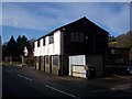
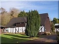
The Old Granary Forge
On the Pilgrim's Way. Part of Tatsfield Court Farm.
Image: © David Anstiss
Taken: 17 Jan 2010
0.04 miles
4
Barn in Tatsfield Court Stables
Seen from a bridleway leading through the farm, from Clerk's Lane towards the Pilgrim's Way.
Image: © David Anstiss
Taken: 17 Jan 2010
0.04 miles
5
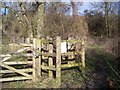
Kissing Gate near Tatsfield Court Farm
This gate is on a footpath from the farm on the Pilgrim's Way, towards The Avenue, Betsom's Hill. The gate leads into the open space land. See Image for more details.
Image: © David Anstiss
Taken: 17 Jan 2010
0.06 miles
6
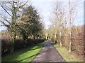
Bridleway in Tatsfield Court Farm
This short bridleway leads from the Pilgrim's Way towards Clarks Lane.
Image: © David Anstiss
Taken: 17 Jan 2010
0.08 miles
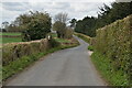
8
Footpath on the Pilgrim's Way
This lane leads from Titsey towards Chevening. The footpath on the right leads across a field towards the B2024 Croydon Road. The track on the left is a bridleway leading to Clarks Lane through Tatsfield Court Farm.
Image: © David Anstiss
Taken: 17 Jan 2010
0.11 miles
9
Track in Hill Park
This track leads of the main footpath from The Avenue to the Pilgrim's Way. The track leads into the open space land managed by Surrey Wildlife Trust. See Image for more details.
Image: © David Anstiss
Taken: 17 Jan 2010
0.11 miles