IMAGES TAKEN NEAR TO
Goodley Stock Road, WESTERHAM, TN16 1TW
Introduction
This page details the photographs taken nearby to Goodley Stock Road, TN16 1TW by members of the Geograph project.
The Geograph project started in 2005 with the aim of publishing, organising and preserving representative images for every square kilometre of Great Britain, Ireland and the Isle of Man.

There are currently over 7.5m images from over14,400 individuals and you can help contribute to the project by visiting https://www.geograph.org.uk
Image Map
Images are licensed for reuse under creativecommons.org/licenses/by-sa/2.0
Notes
- Clicking on the map will re-center to the selected point.
- The higher the marker number, the further away the image location is from the centre of the postcode.
Image Listing (13 Images Found)
Images are licensed for reuse under creativecommons.org/licenses/by-sa/2.0
Image
Details
Distance
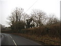
2
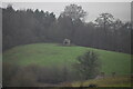
Hilltop Gazebo, Squerryes Park
Grade II listed. https://historicengland.org.uk/listing/the-list/list-entry/1244015
Image: © N Chadwick
Taken: 11 Dec 2020
0.10 miles
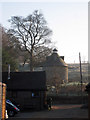
3
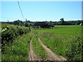
Dutch barn, Lodge Wood Estate, near Westerham, Kent
This farm stands on the opposite side of the road to Squerryes Court.
Image: © Dr Neil Clifton
Taken: 10 Jun 2006
0.11 miles
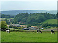
5
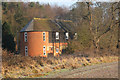
Squerryes Home Farm, Goodley Stock Road, Westerham, Kent
Image: © Oast House Archive
Taken: 29 Dec 2008
0.16 miles
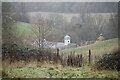
10
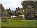
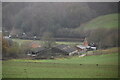
Squerryes Court Lake
Viewed from the south
Image: © Paul Gillett
Taken: 22 Sep 2011
0.19 miles