IMAGES TAKEN NEAR TO
High Street, WESTERHAM, TN16 1SF
Introduction
This page details the photographs taken nearby to High Street, TN16 1SF by members of the Geograph project.
The Geograph project started in 2005 with the aim of publishing, organising and preserving representative images for every square kilometre of Great Britain, Ireland and the Isle of Man.

There are currently over 7.5m images from over14,400 individuals and you can help contribute to the project by visiting https://www.geograph.org.uk
Image Map
Images are licensed for reuse under creativecommons.org/licenses/by-sa/2.0
Notes
- Clicking on the map will re-center to the selected point.
- The higher the marker number, the further away the image location is from the centre of the postcode.
Image Listing (113 Images Found)
Images are licensed for reuse under creativecommons.org/licenses/by-sa/2.0
Image
Details
Distance

2
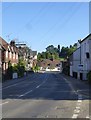
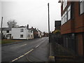
Westerham: view south along the High Street to the Forge
This stretch of the High Street is residential rather than commercial. The road forms part of the A25.
Photo taken early on a mid-summer evening.
Image: © Stefan Czapski
Taken: 22 Jun 2018
0.00 miles
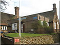
3
Westerham: The Forge
This stands at the corner where Mill Lane meets the High Street - as the A25 heads out of town to the south and west.
The site is close to a mill pond, so it may well have been that water power was used in the days when this was a working forge.
Image: © Stefan Czapski
Taken: 22 Jun 2018
0.00 miles
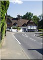
4
Royal British Legion, Westerham Branch
On Mill Lane, close to the A25 Westerham High Street.
Image: © David Anstiss
Taken: 13 Mar 2010
0.03 miles
5
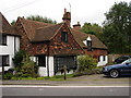
Corner House
Quaint building at one of the bends in High Street. Very low ceilings.
Image: © Ian Paterson
Taken: 10 Sep 2008
0.03 miles
7
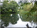
Pond formed by the infant River Darent near Westerham
The source of the River Darent is some springs in the grounds a little to the way south of here - see https://www.geograph.org.uk/photo/4414988 Here it flows towards Westerham through the Squerryes Estate and forms this pond just before it turns east.
For more about the Darent see http://en.wikipedia.org/wiki/River_Darent
Image: © Marathon
Taken: 22 Sep 2019
0.05 miles
8
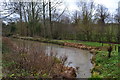
Stream flowing into pond beside High Street, Westerham
Image: © David Martin
Taken: 24 Dec 2012
0.05 miles
9
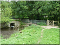
Footbridge over River Darent
Mill Lane is on the other side. The discharge under Mill Lane is from a pond, now ornamental.
Image: © Robin Webster
Taken: 27 Jul 2011
0.06 miles
10
The River Darent, Westerham
It's just a trickle here but widens out towards Dartford
Image: © David Howard
Taken: 8 Jan 2017
0.07 miles