IMAGES TAKEN NEAR TO
Farley Croft, WESTERHAM, TN16 1SA
Introduction
This page details the photographs taken nearby to Farley Croft, TN16 1SA by members of the Geograph project.
The Geograph project started in 2005 with the aim of publishing, organising and preserving representative images for every square kilometre of Great Britain, Ireland and the Isle of Man.

There are currently over 7.5m images from over14,400 individuals and you can help contribute to the project by visiting https://www.geograph.org.uk
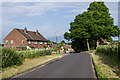
Image Map (Loading...)


Getting Data...Please wait
Leaflet Map data © OpenStreetMap
Images are licensed for reuse under creativecommons.org/licenses/by-sa/2.0
Notes
- Clicking on the map will re-center to the selected point.
- The higher the marker number, the further away the image location is from the centre of the postcode.
Image Listing (24 Images Found)
Images are licensed for reuse under creativecommons.org/licenses/by-sa/2.0
Image
Details
Distance
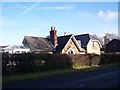
1
Croft Road
1960s estate off Croydon Road.
Image: © Ian Capper
Taken: 21 Jun 2013
0.10 miles
2
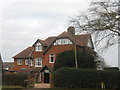
Farlowe
Large house on Beacon Hill, facing Farley Common.
Image: © David Anstiss
Taken: 13 Mar 2010
0.10 miles
3
Mill House
On the B2024 Croydon Road. Beside Cathedral Cottage.
Image: © David Anstiss
Taken: 17 Jan 2010
0.12 miles
4
Cathedral Cottage
On the B2024 Croydon Road.
Image: © David Anstiss
Taken: 17 Jan 2010
0.12 miles
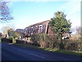
5
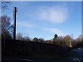
Mobile Phone Mast on the B2024 Croydon Road
This mast is in Southern Water's Pressure Reducing Station on the junction of the B2024 Croydon Road (on the right) and Fairley Lane (in front).
Image: © David Anstiss
Taken: 17 Jan 2010
0.15 miles
6
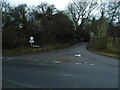
Farley Lane at the junction of Croydon Road
Image: © David Howard
Taken: 16 Dec 2012
0.15 miles
7

Croydon Road
On the outskirts of Westerham. In the right background is Farley Lane and on the right is Westerham Pressure Reducing Station, operated by Southern Gas Networks.
Image: © Ian Capper
Taken: 21 Jun 2013
0.17 miles
8
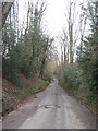
Farley Lane
This lane leads from the A25 Westersham Road up towards Farly Common, and then onto the Croydon Road.
Image: © David Anstiss
Taken: 13 Mar 2010
0.19 miles
9
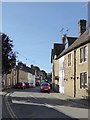
Westerham: New Street
Photo taken looking north from a point just off the High Street. The main building material seems to be local sandstone - in contrast with Stretton Terrace (nearby) which is brick-built: http://www.geograph.org.uk/photo/5817819
Image: © Stefan Czapski
Taken: 22 Jun 2018
0.19 miles
10
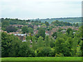
View over Westerham
The west end of town.
Image: © Robin Webster
Taken: 27 Jul 2011
0.20 miles